|
|
Coordinate Systems (Datum Planes) |
|
|
|
The scene coordinate systems are global and local planes that contain important reference locations and define the XYZ coordinate system. Although always present in the scene, displaying it is optional. The scene coordinate system is available per IronCAD Scene. When the Global Coordinate System is displayed, it is represented by three planes intersecting at a 0,0,0 global reference point. Consider the scene coordinate system as the "floor" or "walls" of the scene, even though you are able to position shapes and parts through or below it. It can be a helpful aid in positioning and orienting shapes.
The scene coordinate system is also critical in manipulating the camera. In using the camera, you may need to specify certain directions or dimensions, which are expressed in terms of scene coordinates: length, width, and height (L, W, and H, respectively), relative to the scene datum axes.
In addition, these planes can be used for:
-
Drag & Drop – Drag & Drop from the Catalog will allow snap placement on each plane.
-
Positioning:
-
-
TriBall - TriBall positioning by default will snap to the Planes while displaying the position information.
-
3D Curve - 3D Curve Creation will snap to the Planes while displaying the position information.
-
Position Dimension – Turn on Position dimensions (Under View Menu) for referencing Global positions for Part\Assemblies.
-
-
Sizing – Using Intellishape Handles, hold the Shift Key to allow snapping to the Planes.
-
Starting Profiles – Right-click on any Plane to Create a Profile based on the selected planes origin and orientation as well as an Offset Profile.
Local Coordinate Systems can be created to aid in creation from specific location. Click Coordinate System from the Create-Reference Menu to create a plane at a desired location. When this plane is created, it will be set as the active plane. This means that all position information will refer to this plane. In the scene browser, right-click on any desired plane to make it the active plane. If all coordinate systems are set to not active, then the Global Coordinate System will become the active plane.
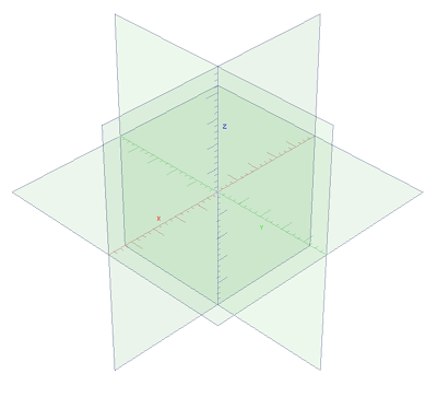
Scene Global Coordinate System
To display the scene coordinate systems, either select Coordinate System from the View menu or right-click the scene background, select Show from the pop-up menu, and then check Coordinate System on the Show properties sheet of the Scene Properties.
If the Coordinate System is too small to see, or if its line spacing is not satisfactory, you can adjust the settings. Select Coordinate System from the Format menu and adjust its size and spacing by editing the values in the Coordinate System dialog box.
When the Coordinate Systems are on, selections (like TriBall, Drag & Drop, Handle Snap, etc) will highlight and select the planes. If geometry is present in the scene, highlighting will revert to the geometry in the scene over the planes.
Default Drag & Drop behavior if dropped in the scene (not selecting a plane) will drop to the 0,0,0 location of the scene.
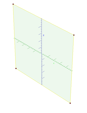
Coordinate System plane highlight
To select a Coordinate System Plane from the scene:
-
Select on the outside edge of any plane to highlight the plane.
-
Right-click on the outside edge of the plane to access options:
-
Active – Active/Deactivate the local coordinate.
-
Hide\Show Plane – Hides\shows the selected plane from the scene view.
-
Show\Hide Plane Gird – Shows\Hides Grid on selected Plane (removes Major and Minor Ticks).
-
Create Profile – Create profile based on the selected planes origin and orientation.
-
Create Offset Profile – Create a profile based on the selected planes origin and orientation at an offset distance.
-
Create Section Profile - Create a profile based by section geometry that intersect the plane.
-
Format Coordinate System – Formats the display of the planes including Grid line, Grid spacing, Size, Behavior, and Snap options.
-